


The scope of research conducted in the Department also includes a wide range of issues related to geodesy and cartography, including mining geodesy and protection of mining areas.
Research activities involve geodetic measurements, photogrammetry, remote sensing, cartography, spatial information systems, geoinformatics, and other.
Major research areas:
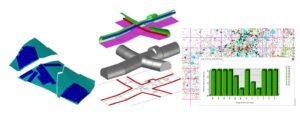
- Analysis of cartographic projections and coordinate systems, in particular, evaluation of accuracy and development of transformation parameters of local flat rectangular coordinate systems used to the state system with software in the GIS class system.
- Technology of creating digital maps and spatial information systems including: designing models for spatial databases and geographical information systems (GIS), developing algorithms for feeding spatial databases, developing methods of cartographic visualization of spatial databases, creating solutions supporting decision-making processes with the use of GIS systems to be used in administration and industry units, in particular also solutions to be used in mining.
- Use of modern surveying equipment in the field of basic work in land surveying and mining, including:
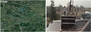
- the use of airborne laser scanning to create elevation models of land surface changes,
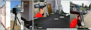
- implementation of surveying measurements, including inventory of roadways, slopes and their deformations, measurements of deformations of buildings based on low-range photogrammetry using precisely positioned unmanned aircraft equipped with high-resolution cameras and based on long-range terrestrial laser scanning technology.
- identification and inventory of damage to buildings based on low-range photogrammetric measurements carried out using unmanned aerial vehicles equipped with high-resolution video and thermal cameras.
- laser scanning of terrestrial objects and methodology of 3D model development, including the inventory of deformation of buildings using terrestrial laser scanning technology and manual scanning.
- Design of systems for monitoring land surface displacements using GNSS and radar interferometry, development of methodology for automatic change detection,
- Improving the methodology of surveying measurements and calculations related to the protection of the surface and objects against the impact of mining exploitation in the period of mining exploitation and during the process of closing down the mines.
- Methods of predicting deformation of mining areas using computer techniques, including numerical modeling of deformation process of land surface caused by underground and open-pit mining works as well as rock mass drainage processes using the method based on cellular automata theory and methods based on geometric-integral theory.