


Education during the first four semesters of engineering studies covers common curricular content. In the fifth semester, a specific engineering field of study is selected. These are: Engineering and Industrial Geodesy, Geoinformatics and Mining Surveying. For the master’s degree you can choose from Engineering and Industrial Surveying or Geoinformatics and Geodesy.
The first degree of studies lasts 7 semesters. Upon completion of the first degree of studies, the graduate obtains the professional title of Engineer. The second degree of studies lasts 3 semesters. Upon completion of the second degree of studies, the graduate obtains the title of Master of Science (MSc) in engineering. The study plan meets the requirements of the Geodetic and Cartographic Law and the executive regulations to the Act, including the Regulation of professional qualifications in the field of geodesy and cartography.
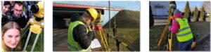
Graduates of the studies are prepared to work with the use of the most modern measurement and computing techniques and the use of geoinformatic technologies. They are prepared to run their own
You will find a job in:
- in surveying companies.
- Self-governing and government administration units, including geodetic and cartographic administration.
- enterprises dealing with the processing of geodetic data using IT tools.
- research and development centers and research institutions,
- mining commerce.
You will gain knowledge and skills in the following areas:
- the implementation of geodetic work in the field of situational and height measurements, the implementation and inventory measurements, basic geodetic measurements, demarcation and divisions of real estate, geodetic investment service, geodetic arrangement of agricultural and forest areas, editing maps, photogrammetry and remote sensing.
- use of modern techniques of geodetic, satellite, photogrammetric and remote sensing measurements, including the use of unmanned aerial vehicles (drones) and laser scanning.
- numerical processing and presentation of measurement results in surveying environments of computer programs with the use of programming languages.
- data acquisition and implementation, updating and modeling and analyzes of spatial databases in GIS program environments.
- implementation of geodetic measurements in mining enterprises.